top
New Tools For New World

Case Studies

Offshore North Sea Case Study

Location:

North Sea

carte1

Project:

  • Mature but under-explored area
  • Recent discoveries in adjacent areas opening new plays
  • A number of fallow areas which have unidentified additional potential

Challenge:

  • Blind test: no prior knowledge of the area
  • Complex Geology: Salt diapirs, mini-basins, early rifting, inversion and oblique-slip reactivation, Upper Cretaceous chalk interval etc…
  • Key target intervals sit beneath shallower complexity which can interfere with interpretation.

Objective:

  • Rapid Interpretation of the geology
  • Identify plays and prospectivity
  • Test the blind study generated results against drilled structures

Seis-H: Pre-Interpretation Processing:

  • 3D seismic volume of ~1,000 km2 was input as is in Seis-H.
  • One mouse click and less than an hour later, ~7,000 GeoPopulations (surfaces) were automatically output along with Structure, Amplitude and Fitness attributes.
  • The surface extraction process is unsupervised and unbiased: no prior information (such as initial model or well data) is required.
  • The queryable database of GeoPopulations was reviewed using the Seisnetics Viewer.

Key Findings:

  • The 3D seismic volume was explored much more efficiently: the Seisnetics viewer allows to browse the queryable database of GeoPopulations seamlessly and identify easily both regional and reservoir-scale features:

  • New plays and prospects were identified:

  • key2

Seis-H
Key Benefits To
The Interpretation Team:

  • Seis-H pre-interpretation analysis is fully automated and is applied consistently throughout the input dataset, thus producing a database of unbiased and high-quality attributes.
  • The surfaces were extracted in less than one hour, thus allowing the interpreters to spend more of their valuable time focused on understanding the results, identifying new plays and prospects and analyzing their economic potential.
  • Time-efficient, Seis-H encouraged more multi-disciplinary collaboration between technical teams and management.
  • Consequently, the collective knowledge base of the group could be integrated. This enabled a better understanding of risk and accelerated the decision-making process.

Bunda Case Study

Location:

Canning Basin, Western Australia

cs2

Objective:

  • Develop a better understanding of the nature of reservoir, seal, structure and fluid flow for the existing oil fields, and thereby identify additional economic opportunities.
  • Identify surrounding leads and new prospects.

Seis-H: Pre-Interpretation Processing:

  • The Bunda 3D seismic volume of ~320 km² was input as is in Seis-H.
  • One mouse click and a couple of hours later, thousands of GeoPopulations (surfaces) were automatically output along with Structure, Amplitude and Seismic Facies maps (Fitness attribute).
  • The surface extraction process is unsupervised and unbiased: no prior information (such as initial model or well data) is required.
  • The queryable database of GeoPopulations was reviewed using the Seisnetics Viewer.

Key Findings:

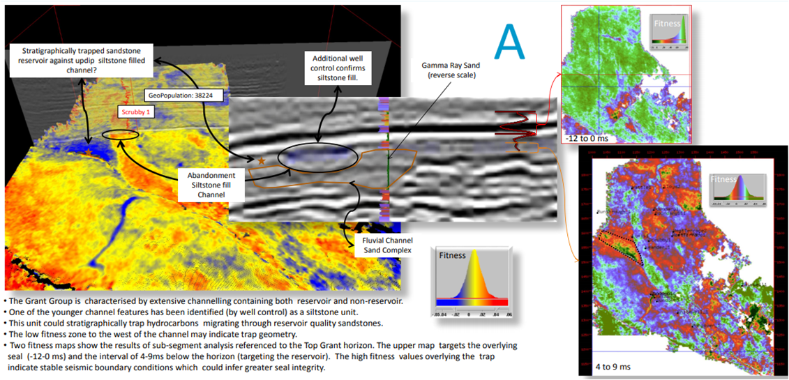
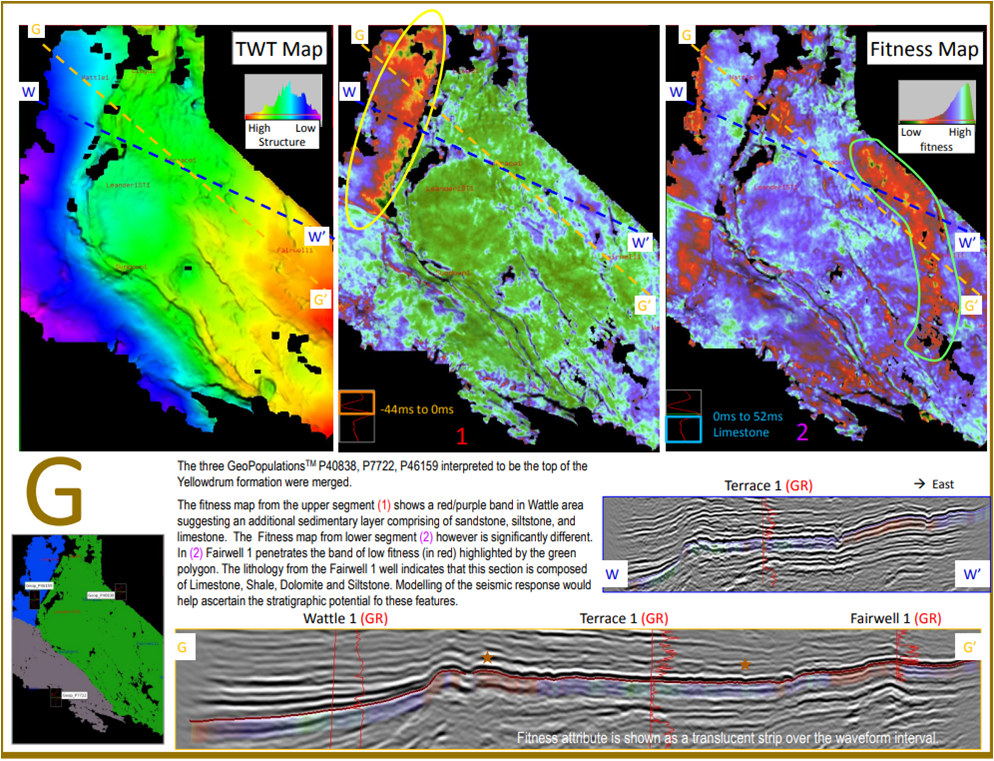
The observation of the GeoPopulation database revealed many new insights and opportunities, amongst them:

Potential stratigraphic trapping of reservoir against fine grained channel fill

  • More than a simple surface, a GeoPopulation is a population of genetically and spatially related waveforms. The Fitness attribute map, which highlights the variability of the waveform across the surface, opens up a new approach for seismic facies mapping.

  • A GeoPopulation was identified as the Top Grant Formation (often considered to be the interface between top reservoir and regional seal). An analysis of the Fitness on upper and lower portions of the waveforms was performed in the Seisnetics viewer, in order to target more specifically the overlying seal and the reservoir itself.
  • This sub-waveform analysis combined with the integration of well logs information allowed to highlight potential trapping of reservoir against fine grained channel fill.

  • sc2-img1

Leads showing structural closures and sub-waveform analysis analogous to nearby production zones

sc2-img2

Stratigraphic Features of interest

sc2-img3

Seis-H
Key Benefits To
The Interpretation Team:

  • The use of Seis-H to extract all the surfaces meant that there was never a shortage of surfaces and consequently, most of the time was spent thinking about the significance of the results rather than the mechanics of surface extraction.
  • Having the queryable database of all surfaces enabled the interpreter to quickly review and interpret the surfaces as desired. Consequently, the response time between a new thought and the testing of that concept was minimized, making it an efficient way of cycling through a range of different data consistent scenarios.
  • The surface extraction process being unbiased as well as fast, there was more opportunity for more collaborative interaction between different geoscience disciplines using the database of surfaces as a common point of reference.
  • The automated and fast extraction of all surfaces maximized the time spent on interpretation and prospect generation.
  • Link to associated conference paper

Barrolka Case Study

Location:

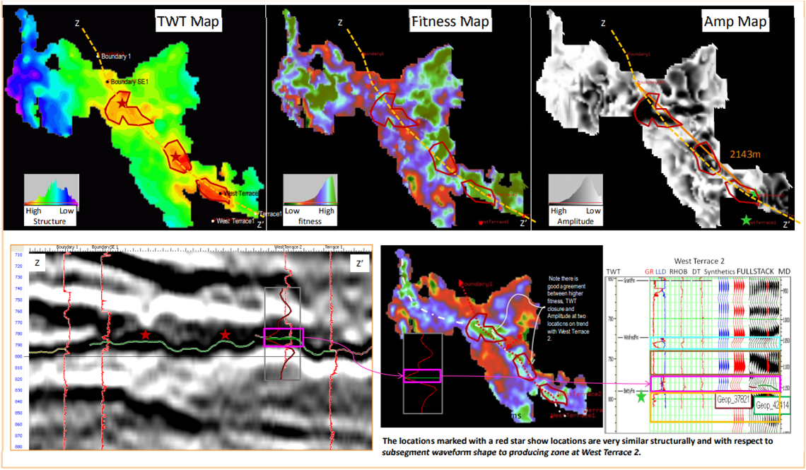
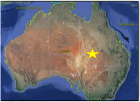
Cooper-Eromanga Basin, SW Queensland (Australia)

sc3-carte

Main Reservoir Units:

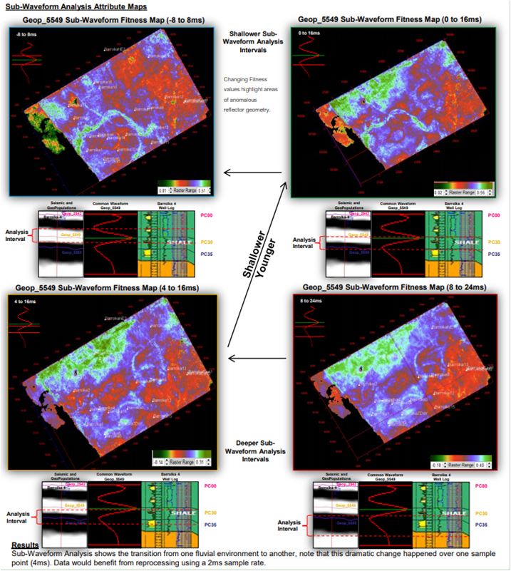
Permian, Fluvial channel sands PC30 and PC35

Challenge:

  • The thicker PC35 channel sands were the primary target of drilling. However, they were difficult to produce as the sands were of variable reservoir quality. The thinner and shallower PC30 sands were the best producers.
  • Channel Sands PC30 and PC35 which are fairly elusive, not regionally extensive and at the limit of the seismic resolution, need to be better understood to get the most out of the asset.

Seis-H: Pre-Interpretation Processing:

  • The Barrolka 3D seismic volume of ~ 200 km² was input as is in Seis-H.
  • One mouse click and less than 15 minutes later, ~800 GeoPopulations (surfaces) were automatically output along with Structure, Amplitude and Fitness attributes.
  • The surface extraction process is unsupervised and unbiased: no prior information (such as initial model or well data) is required.
  • The queryable database of GeoPopulations was reviewed using the Seisnetics Viewer.
  • Geop_5549 was identified as a GeoPopulation of interest to better understand the reservoir.
  • The Fitness attribute of Geop_5549 was recalculated on the fly over portions of the waveform (sub-waveform analysis) in order to see details beyond the standard seismic resolution.
  • Available wells are uploaded ( as validation only) in the Viewer, helping turn the Seismic Fitness Facies Maps into Geological Facies maps.

Key Findings:

  • Seis-H sub-waveform analysis of the fitness attribute was able to map the PC30 channel sands whilst also revealing further stratigraphic character.
  • Seis-H sub-waveform analysis revealed a step change in the fluvial environment over a 4ms interval between the PC30 and PC35 reflectors.
  • The ability to map these subtle stratigraphic channel features and how they change over the reservoir interval was the key to the understanding and exploitation of this resource.

  • sc3-img2

Seis-H
Key Benefits To
The Interpretation Team:

  • Seis-H pre-interpretation analysis is fully automated and applied consistently throughout the input dataset, thus producing a database of unbiased and high-quality attributes.
  • The surfaces were extracted in a timely manner, thus allowing any interpreter to spend more of their valuable time focused on understanding the results and their economic potential
  • Time-efficient, Seis-H encouraged more multi-disciplinary collaboration between technical teams and management.
  • Consequently, the collective knowledge base of the group could be integrated. This enables a better understanding of risk, accelerates the decision-making process.
-->